
The Permian Basin in West Texas and Southeastern New Mexico is a “super basin,” representing one of the most prolific oil and gas-producing regions in the United States. More than 35.6 billion barrels of oil and about 125 trillion cubic feet of natural gas had been produced as of January 2020. The basin is approximately 250 miles wide (east-west) by 300 miles long (north-south) and consists of two primary areas of production — the Midland Basin in the east and the Delaware Basin in the west — separated by the Central Basin Platform.
After a century of oil production focused on conventional oil fields and vertical wells, the last decade has seen a shift in focus to unconventional production with horizontal wells and extensive hydraulic fracturing programs to exploit reservoirs with very low permeability.
ABOUT THE AUTHOR
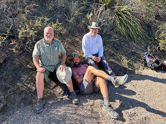
The authors recently completed a field geology campaign studying outcrops near Marfa, Texas. Dr. David Ferrill (left) is a structural geologist with expertise in diverse tectonic regimes, and international oil and gas exploration and production experience. He has extensive expertise characterizing reservoirs and aquifers, interpreting tectonic stress fields and analyzing mechanical stratigraphy, rock deformation and fracture mechanisms, and serves as principal investigator for the Permian Basin consortium. Dr. Adam Cawood (center) is a structural geologist specializing in close-range remote sensing for quantitative structural analysis. His research focuses on natural deformation processes, with an emphasis on leveraging structural data for improved understanding of the subsurface. Dr. Kevin Smart (right) is a structural geologist with extensive expertise in computational solid mechanics. He is manager of the Earth Science section in the Space Science Division and part of a team conducting an integrated program of structural geology and geomechanics research for the energy industry.
Unconventional production techniques reversed a production downturn, allowing the basin to exceed its previous peak in the early 1970s. In 2021, the Permian Basin accounted for more than 41% of total U.S. crude oil production and more than 15% of total U.S. natural gas production. As of 2019, the Energy Information Administration estimated remaining proven reserves in the Permian Basin exceed 12.1 billion barrels of oil and 49.9 trillion cubic feet (Tcf) of natural gas, making it one of the largest hydrocarbon-producing basins in the United States and the world.
DETAIL
Unconventional oil and gas reservoirs, or plays, are accumulations where oil and gas are tightly bound to the rock.
The relatively flat surface topography across most of the Permian Basin belies the complexity of its subsurface geology. The layers of rock record a long geologic history, including four major geologic events caused by the shifting of the Earth’s tectonic plates. During approximately 323 million years of tectonism, the Permian Basin developed and accumulated sediment including the lower Permian Wolfcamp shale. This organic-rich oil and gas source rock extends across the subsurface of the Permian Basin and represents the most prolific tight oil and shale gas-bearing formation in the region. This unconventional reservoir and layers below were deposited around the uplifts of the Ancestral Rockies and Ouachita deformation, geologic events that occurred when the continents now represented by North America, South America and Africa collided around 300 million years ago. The rock deformed due to stress from continental tectonic events, as layers folded and shifted, changing shape and size. The deformation caused regionally variable fault and fracture networks throughout the rock layers.
DETAIL
Geologic strata are layers of rock, each with distinguishing properties or attributes, chronicling the history of the Earth.
The earlier Ouachita and Ancestral Rockies tectonic events influenced basin depth and the thickness and sediment makeup of the strata deposited during these mountain-building events. Younger tectonic events occurring after these sedimentary layers were buried and solidified included the Laramide orogeny that formed the modern Rocky Mountains and the subsequent deformation associated with formation of the Basin and Range Province. Both of these tectonic episodes had variable and widespread impact on faulting and fracturing of rock layers across the Permian Basin region.
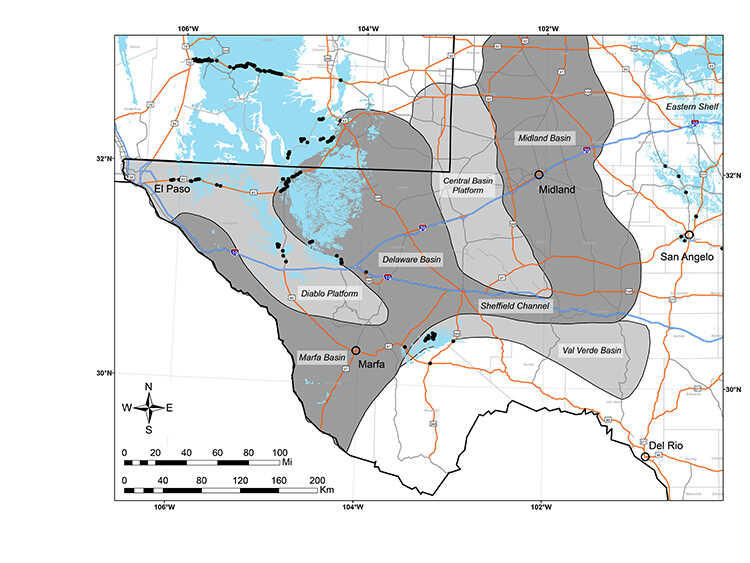
This regional map of West Texas and southeast New Mexico shows the location of Midland Basin, Delaware Basin and Marfa Basin within the overall Permian Basin complex. Outcrops of Permian strata are shown in light blue, and black dots indicate locations of some of the outcrops investigated by SwRI’s Permian Basin consortium.
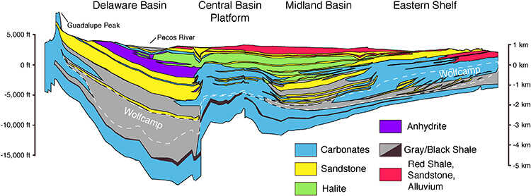
Image courtesy Geological survey energy resources program/ Matchus and Jones (1984)
This figure illustrates the layers of rock present in the Permian Basin, particularly the Wolfcamp shale deposits.
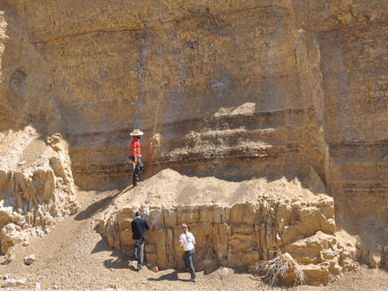
SwRI geologists map fractures in Permian strata as part of the Permian Basin consortium. The project focuses on characterizing the properties and formation mechanisms of faults, fractures and other deformation features related to the Ancestral Rockies, Ouachita, Laramide, and Basin and Range tectonic events.
Natural deformation features such as fractures and faults in the Permian reservoirs and associated strata from all of these overlapping tectonic events have wide-ranging yet poorly understood impacts on oil and gas exploration and production. Hydraulic fracturing is considered essential to economic success in unconventional reservoirs made up of layers of fine-grained rock with low permeability. Natural fractures can also be extremely important for providing pathways to deliver hydrocarbons to the well for effective production. Other considerations include understanding how pre-existing faults can move (slip) — due to wastewater injection, hydraulic fracturing and/or production — and produce earthquakes.
Phase 1
SwRI launched the Permian Basin consortium in 2017 to help the oil and gas industry better understand and predict faulting, fracturing and folding and how they relate to mechanical stratigraphy, which represents rock mechanical properties, layer thicknesses and interface behavior between rock layers. From 2017 to 2019, Phase 1 explored natural surface outcrops, as well as road cut and quarry exposures, to understand how mechanical stratigraphy and tectonic setting influence natural fracturing and related deformation. These investigations included fieldwork at approximately 400 outcrop locations in and around the Permian Basin, characterizing faults and fractures as well as sampling and analyzing mineral-filled fractures (veins) for fluid inclusions. The team used fluid inclusion analyses and stable isotope geochemistry of vein materials to determine geologic conditions such as depth, temperature, pressure and water source at the time of vein formation. The team also analyzed core samples from the basin and correlated subsurface mechanical stratigraphic and vein analyses of core samples collected in the region.
Phase 2
DETAIL
The Laramide orogeny refers to a series of mountain building events affecting western North America in the Late Cretaceous and Paleogene periods.
From 2019 to 2022, the consortium built on Phase I results, including aggregation and analysis of subsurface fracture data from dozens of Permian Basin wells contributed by consortium members. Mineralogic analyses of outcrop samples augmented mechanical stratigraphy datasets for outcrop fracture studies. Phase 2 refined estimates of the conditions associated with faulting and fracturing through detailed fracture analyses of outcrops in and around the Delaware and Midland Basins and performing additional vein sampling and fluid inclusion analyses of calcite veins.
DETAIL
The Wolfcamp shale was deposited in the Permian region around 280–295 million years ago.
Results from the first two consortium phases showed how deformation styles vary depending on regional tectonic context and local structural position. Our studies provided detailed insights into how mechanical stratigraphy influences fault and fracture properties at bed and formation scales, controlling the dimensions (particularly height), abundances, orientations and geometries of faults and fractures. The work has documented how weak beds — rock layers of sufficiently lower strength than adjacent layers — terminate fractures and faults. Understanding these influences not only improves natural fracture prediction in the subsurface, but the research results also provide analogs for newly formed or reactivated subsurface fractures associated with hydraulic fracturing. Fluid inclusion studies from outcrop samples provide important evidence that fractures now observable in outcrops at the surface formed at depths up to several miles, on par with current depths of horizontal well drilling and hydraulic fracturing in the basin, implying that similar fractures are likely at reservoir depths. Many of the sampled veins contain liquid hydrocarbon inclusions. Ultraviolet fluorescence analyses indicate a range of oil types, recording progressive fluid trapping over time as oil migrated through the rocks.
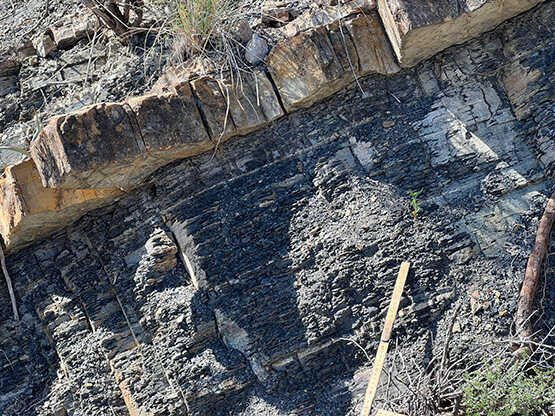
In the Permian Basin, sandstone beds develop complicated, dense and interconnected fracture networks, whereas Wolfcamp shales may be relatively unfractured or develop independent fracture networks, resulting in limited fracture connectivity across the different layers of rock.
Small-displacement faults represent the largest fractures, forming the backbone of the fracture-controlled permeability network.
Phase 3
DETAIL
Calcite veins are common in rocks as the products of fluid movement and mineral deposition along fractures. These structures constrain the geochronology of basin deformation, fracture and fault system evolution, and fluid movement including oil and gas migration through the fault and fracture network.
SwRI just launched the third phase of the Permian Basin consortium, which will run through 2026. Phase 3 leverages work completed in Phases 1 and 2 with particular focus on developing quantitative relationships for subsurface deformation prediction. Planned research includes surface and subsurface investigations to characterize the mechanical stratigraphy and natural deformation that influence stimulation and production in the Permian Basin. Planned tasks involve an increased emphasis on quantitative outcrop-based structure and mechanical stratigraphy data collection. Goals include developing causal relationships for interpreting deformation based on layer age, rock type, mechanical stratigraphy, tectonics and structural constraints, culminating in a predictive workflow.
An exciting project expansion in Phase 3 involves new field investigations of a series of outcrops around the Chinati Mountains southwest of Marfa, Texas. In particular, the 5,600-foot-thick Wolfcampian age shale and sandstone deposited in basin and slope settings within the Marfa Basin provide excellent outcrop analogs for productive reservoirs in the Delaware and Midland Basins.
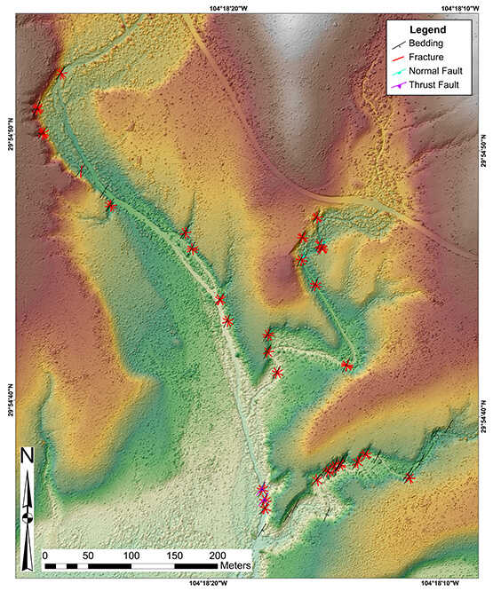
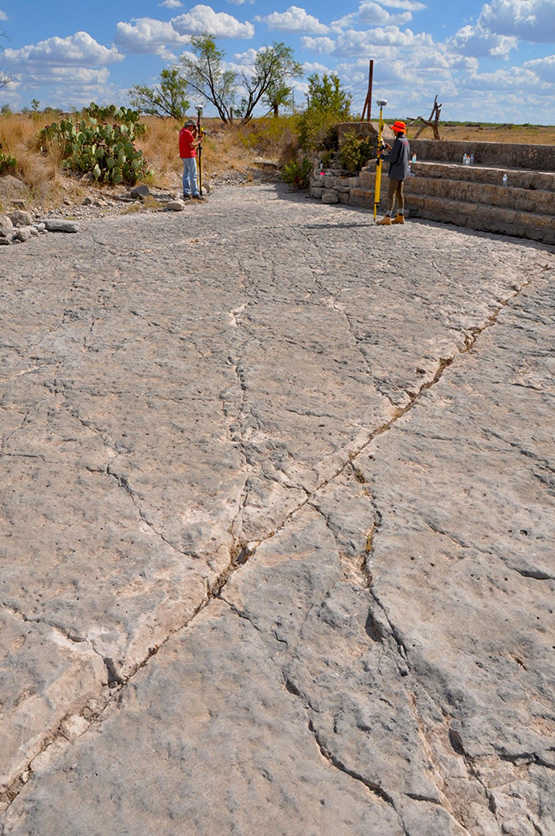
Digital photogrammetry generates detailed digital topographic maps for mapping and locating detailed structural measurements of faults, fractures and bedding in outcrops.
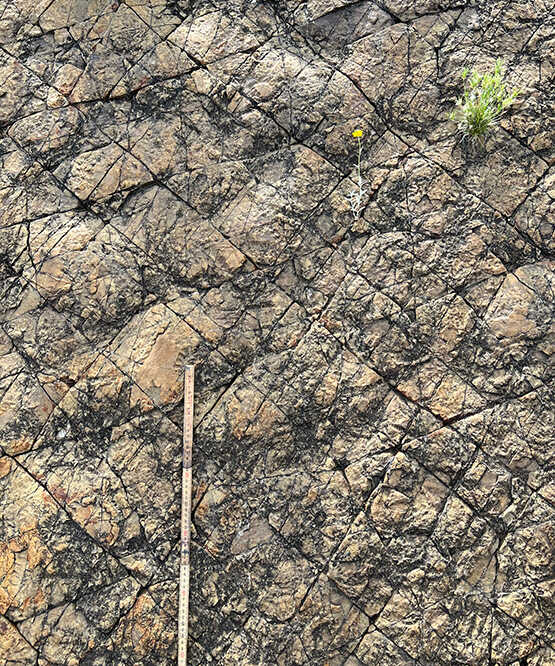
Geologists study cross-cutting sets of fractures such as the ones shown here to understand regional stress changes during the tectonic evolution of the basin.
SwRI geologists used internal funding to collect outcrop data, securing access to private ranches critical to the success of this project. Results of this research campaign provide the foundation for additional follow-on work planned for Phase 3 of the Permian Basin consortium. Outcrops reveal much larger volumes of rock than what can be studied by well or core samples. This “outcrop scale” observation is particularly important to understanding the distribution of deformation “fabrics,” including fracture network and mechanical layering at the scale of a hydraulic fracture treatment (“frac stage”), and fills a missing data gap in understanding of the subsurface.
DETAIL
In geology, fabric describes the orientation or alignment of minerals, grains or structures in a rock associated with deformation or metamorphism, which reveals important information about its tectonic history, stress regime, strain rate and fluid flow.
Phase 3 will continue to study the structures, faults and fractures in reservoirs and associated strata to support planning, production and development-related activities in the hydrocarbon-producing formations of the Permian Basin. Resulting integrated datasets and predictive workflows will support subsurface fracture prediction and geomechanical analyses as well as provide material to train consortium members’ staff to identify the key attributes that affect stimulation and production in the region. Phase 3 kicked off with a meeting and field trip to the Marfa Basin in fall 2023. New members are welcome.
Questions about this story or joining the consortium? Contact David Ferrill at +1 210 522 6082.