
In this Episode
Rumbling and shaking during an earthquake can trigger liquefaction, a dangerous process that causes solid ground to behave like a liquid. This can result in widespread destruction. Our guest today is SwRI geologist and geophysicist Dr. John Stamatakos. He helped develop the American National Standard Probabilistic Seismic Hazard Analysis ANSI/ANS-2.29-2020 (subscription required), which provides information on earthquake hazards at potential construction sites. He’s also part of a team compiling data from around the world to predict where liquefaction is likely to happen. If researchers can pinpoint high risk areas, communities can better prepare.
Listen now as we explore the impact of earthquakes.
Transcript
Below is a transcript of the episode, modified for clarity.
Lisa Peña (LP): Liquefaction happens when the ground loses strength and stability during an earthquake, and it can trigger widespread destruction. Our guest today is part of a team working to predict where liquefaction may occur. So how are past and recent earthquakes contributing to their research? An earth-shaking discussion is up next, on this episode of Technology Today.
[MUSIC PLAYING]
We live with technology, science, engineering, and the results of innovative research every day. Now, let's understand it better. You're listening to the Technology Today Podcast, presented by Southwest Research Institute. Hello, and welcome to Technology Today. I'm your host, Lisa Peña.
Our guest today is visiting San Antonio from Rockville, Maryland, in the Washington, DC area. He's here to talk about earthquakes and better predicting their impact, specifically where they will trigger liquefaction. Dr. John Stamatakos is a Southwest Research Institute geologist and geophysicist, cutting to the core of earthquakes with groundbreaking science. Thanks for joining us, John.
Dr. John Stamatakos (JS): Oh, you're welcome.
LP: So our buzzword today is liquefaction. So tell us, what is liquefaction?
JS: So liquefaction occurs when soils of certain types, especially soils that are saturated with water, lose their strength. And during earthquakes, these soils lose their strength because the repeated cycles of the shaking basically pump up the water, to the point where the grains, or sand grains, or whatever component parts of the soil are no longer in contact, and basically, the soil then behaves as a liquid.
LP: So what type of damage can liquefaction cause?
JS: So in the large examples of damage, it's very extensive. So 1989, Loma Prieta, there was liquefaction that caused the collapse of the Embarcadero Causeway, and that was very disastrous. Recent earthquakes in New Zealand caused widespread liquefaction, and, in fact, destroyed a suburb of about 10,000 homes. 2018, there was a liquefaction event in Indonesia, that also caused a lot of death, maybe 500, 600 people and 1,000 to 2,000 homes also destroyed from liquefaction.
It can destroy building foundations, foundations for bridges. In really big events, it can destroy entire cities. All of the soil behaves now as a liquid, so every building is turned on its side or collapses. It is probably one of the biggest consequences of large earthquakes that causes damage.
LP: Yeah, so does the size of the earthquake, the magnitude, matter? Is it smaller earthquakes don't usually cause liquefaction?
JS: So the larger earthquake probably results in a larger area experiencing liquefaction, but even smaller earthquakes can cause liquefaction. And one of the research areas that we're really looking at in the consortium, that we're working on, is to evaluate how small an earthquake can be and still result in damage. And we're finding now, evidence that even really small events can be devastating, given the right soil conditions.
LP: OK, so walk us through that. How does the earthquake react with the soil, shakes it up and basically makes it into a liquid?
JS: Yeah, so the soil is shaking. When earthquakes occur, they produce this energy that vibrates. And you get these cycles of up and down or lateral back and forth. And so, this lateral cyclic shaking causes the fluid in the pore spaces between the grains to expand.
And if it's occurring fast enough, and that fluid can't escape, the fluid basically expands the soil until the sand grants are no longer in contact with each other. And then it's basically a slurry and it loses all of its strength. So if you have a foundation embedded in it, or you have a pad on top of it, that's going to react as if now it was sitting on top of a pool of water.
LP: So the big issue now is predicting where this is going to happen, because obviously, if there's anything that can proactively be done to secure an area, that's what we would want to do. So Southwest Research Institute is part of the Next-Generation Liquefaction Consortium. So what is the mission of the consortium?
JS: So the consortium was started by groups of scientists in California, specifically Jon Stewart, who was then the Chairman of the Civil Engineering Department at UCLA, working with groups at Berkeley and the University of Washington, to put together a new study to try to improve the modeling and the predictability of the modeling that would go into making assessments of whether or not a soil that you're going to build on would liquefy.
There's been a long controversy about how that's been done in the past. And in fact, there were two groups in California, who had very divergent models. And depending on which model you would use, you would get either, yeah, this soil is safe, you don't take any countermeasures in your construction to, this soil is really bad, you better spend an extra \$200,000, \$400,000, \$400,000,000 in some cases, to construct something that would be safe.
And so, there was this huge uncertainty in the predictability of these equations, and the consortium was founded in order to try to bring all of the leading experts together to come to a common agreement on a new model that everybody could rely on.
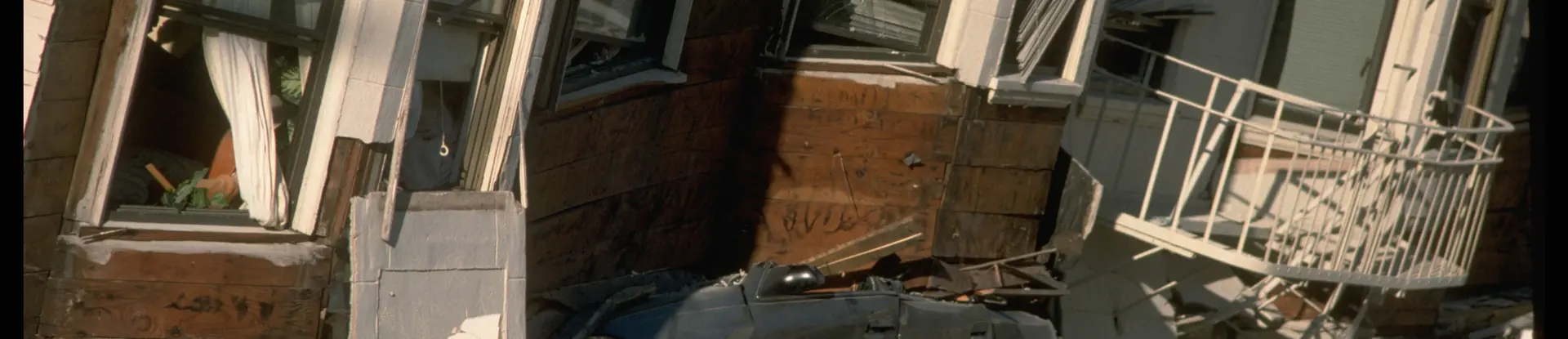
LP: And who is part of the consortium right now?Image
Left to right: Lisa Peña and Dr. John Stamatakos
JS: Well, the consortium was developed out of this group called the Pacific Engineering Earthquake Research Center, PEER. And the main contributors right now are the Nuclear Regulatory Commission. So they're very interested in supporting this, because they need to update their guidance. They rely on some of these older models that are uncertain. So they would like to have a much more state-of-the-art, a much more reliable set of predicting equations, to provide guidance on how they regulate the construction of critical facilities. The California Coastal Commission, the California Highway Department, I can't remember the exact acronym for that group, but those are the types of groups.
And we've been working with some groups in Japan to try to get their interest in the consortium. And the Bureau of Reclamation. So the Bureau of Reclamation is another group that's responsible for a large number of big dams in the Western United States, and liquefaction has a big potential impact on the stability of these large dams.
LP: So there are a lot of entities that play a role in the consortium now, and the goal is to get everybody on the same page, to predict where this will happen. So what type of data are you collecting and studying, right now?
JS: So the first phase of this project, which is now, it's not complete, but a good part of it is established, was to develop a new usable database of observations. We call them case histories. So we've now built the software for it here.
It's accessed through what's called the EERI website. It's an engineering website that's run at the University of Texas. But users can go in and input data of all kinds of observations, from recent or even older liquefaction events.
So the size of the earthquake, any records, any actual recordings of the ground motion, the types of soils, any kind of data collected to characterize the soil, which is a key component in understanding whether or not liquefaction will occur, the extent of the liquefaction, any direct observations from people who went through it, aerial photographs, measurements of displacements, measurements of defamation, all that information gets packaged into what's called a case history database.
Once we have a large number of those, then that's going to form the base data that the expert modelers will use to go in and create these new predictive tools. To say, OK, here's where liquefaction occurred. Here's the energy that was needed to cause a liquefaction. Here's the percent of sand. Here's the percent of clay that was in this soil. All of those things will go into their models to help them make these new better models.
LP: So that collection is underway now. Have you had any insight based on that data? What is the data revealing?
JS: So we talked about a few minutes ago, I think one of the really surprising things is that we're finding out that pretty small earthquakes still result in liquefaction. And so, I think, a focus of some of our new research is going to have to be looking at, how little energy does it actually take, under certain conditions, to liquefy?
Normally, in the past, we've been saying, well, magnitude 6 or smaller earthquake, we wouldn't worry about it. Well, now we're finding examples where liquefaction occurred with a mag 2, 4 and 1/2 earthquake. That has a big implication, because places like Oklahoma, where we're inducing a lot of small earthquakes, now may also have areas that are susceptible to liquefaction if the right earthquake occurs. Or the wrong earthquake occurs in the wrong place, let me put it that way.
LP: So with the smaller earthquakes able to produce liquefaction, it might not cause the widespread destruction of the bigger ones, but several of the smaller earthquakes over time causing liquefaction, does that lead to destruction down the road?
JS: I don't think there's a cumulative or additive effect. I think we have liquefaction, you have that event, and then once the soil regains its strength, so I don't think there's the worry that there's additive damage. It's just that you might have a facility that you've never even thought was susceptible to an event, and if you have earthquake that's really close by, and it's even a small earthquake now, all of a sudden you may have an issue at that critical facility.
LP: So has this been your biggest discovery thus far with this data? What are some other highlights?
JS: I think that to me was the most surprising. I think the rest of what we've sort of collected now is just to try to catalog, and get a good basis for where this might go next. There's some really interesting things that are very technical about what approach. You can use a strain approach, a stress approach, an energy approach, but all of those really need to be sorted out by the way that we hope that the community will come together.
And this structured, expert elicitation process that we envision, bringing them together with meetings, having everybody agree to certain approaches, having everyone go off and test those, come back, see what the results are, and go through that process again. So that's really the next step.
LP: I thought it was interesting you said that the type of soil makes a difference. So what different types of soil are there, and which one is most susceptible to liquefaction?
JS: So that was also a surprising discovery, when we started to catalog these case histories. Classically, the ideas about susceptible soil center on things that are very much composed of sand. So pure sand soils that are saturated with water are thought to be the ones that are most susceptible.
And if there's any content of what we call fines. Fines would be clay material, or other non-sand material. We always thought if there was even just a small percentage of those, that they would bind the soils. But New Zealand showed us that in fact soils that have relatively high fine contents also liquefied. So that's another area that we're really going to have to investigate more, because these traditional models basically ruled out liquefaction of any soil that wasn't really pure sand.
LP: Well, let's talk about New Zealand a little bit, because that has been a big earthquake that you have studied. So that happened Christchurch, New Zealand, February 2011. Huge earthquake. Do you recall the magnitude?
JS: So it actually wasn't a very big earthquake.Image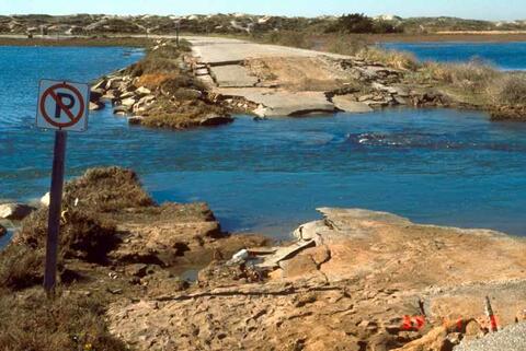 USGS/J.C. Tinsley
Liquefaction and strong tidal action following the 1989 Loma Prieta earthquake destroyed a causeway in Watsonville, CA.
LP: It wasn't very big, right.
JS: It was a, I think, a magnitude 6.3 a magnitude 6.4.
LP: It was the destruction.
JS: It was just the level of the destruction, and the soil there was very susceptible to liquefaction. In fact, there are some YouTube videos you can find of basically looking like waterspouts. That's how much water was being ejected after the event, that just flooded these communities with mud when the soil sort of recompacted after the liquefied event. It was it was surprising.
LP: What have you figured out from that event?
JS: Well, I think the main thing was this observation about that those soils that were not traditionally considered to be that susceptible to liquefaction, because they had a high fine content. I think another aspect of those that were really starting to just appreciate, is that the soils that were liquefied went to a pretty great depth compared to some other events.
Eight to 10 meters of soil liquefaction depth is pretty deep for soil. It usually affects just the upper couple meters of soil. So that was, I think, going to be a surprising thing that we're going to have to evaluate. But I caution jumping too much forward, because we have all these other case histories that all these other researchers are now loading into our database.
And I think it will be interesting, once we have that established and we bring everyone together to talk about it, then we'll really see the full range of soil types, of earthquake types, that have caused liquefaction damage.
LP: Jumping now to an earthquake in Indonesia in 2018. What have you learned from that particular event?
JS: There hasn't been a lot of data that's been added from that event. I actually just looked that up on my way over here, to say, oh, yeah, there was another one. What I understand is that the original damage was attributed to Tsunami. But I think the eyewitness reports and some of the more detailed studies are revealing that it was actually liquefaction that caused the majority of the damage.
So that, I think, will be a focus where we're going to have to see if we can find some people who want to go to Indonesia, and do some real detailed investigations, and add that to our database.
LP: A good trip opportunity there. So a big newsmaker this summer, two back-to-back earthquakes shook the area near Ridgecrest, California. That was in early July. There was a 6.4 magnitude, and then a 7.1. Did you learn anything from those two back-to-back events?
JS: Yeah, in fact, there was also a 5.3 that was grouped into what we call the main shocks, three interesting main shocks. And that was a really interesting event, because they occurred on two faults that are oriented 90 degrees to each other. The first earthquake on a unrecognized fault in an interesting orientation. That was more almost east-west.
And then the second big event on a north-northwest, south-southeast tracking fault that we did know about, called the Little Lake Fault. And what that showed us is what some people had predicted for a long time, that the stress that's unloaded on one earthquake event, can actually take that, some of that stress can then get loaded onto another fault, and cause that fault to rupture as well.
And that's what we think happened here, that the first earthquake released the stress that was sitting there ready to go. And that stress then was added to the existing stress on the bigger fault, and that caused the bigger earthquake.
LP: We're talking so much about earthquakes, but how many of us really understand what happens during an earthquake? So can you explain the science of an earthquake? What happens during an earthquake?
JS: So an earthquake is the release of a huge amount of tectonic stresses that get built up on the fault. And I think the easiest analog is that think about putting your two hands together and pressuring them first into each other as hard as you can, and then trying to slide one past another. And initially, the friction in your hands is stronger than your ability to move your hands past one another, but eventually you could build up enough so the hands will suddenly and dramatically slip by one another.
That's essentially the stick-slip model, we call it, for earthquakes. So the tectonic stresses build up over time, until the frictional resistance of that fault plate can no longer hold that stress, and you get a rapid relaxation. And that produces a huge amount of energy, that then radiates out in all directions. And that's what produces all the shaking.
LP: So is there really any way to protect buildings from the destruction of an earthquake? What are the solutions?
JS: There are a lot of solutions, and some work better than others. One of the things I think that's really starting to take hold in the community is a little bit of advance warning. So the energy that gets produced by an earthquake involves a series of different kinds of waves. And the first waves that emanate, that travel very fast, are called the P-waves or primary waves.
They're not very destructive, they're not very big, but they can arrive seconds or even minutes before the really destructive waves come. So some communities and some organizations are looking at doing some preemptive things like, if they sense a P-wave, all the garage doors at all the fire stations will open so that the earthquake won't cause enough damage that they can't get the garage doors open afterwards.
Elevators will move to the nearest floor, and the elevator doors will open so that everyone can evacuate. Computers will backup their hard drives immediately, so that key data may get preserved. Things like that. So we might get a little bit of an early warning. That's one. Second, is to design buildings that can withstand that kind of shaking. And there's actually a lot of experience gained from past earthquakes, in how that might go.
So the simple things are to make sure you don't have any big facades in the front of buildings in earthquake zones, where they can fall down on people walking by. Use very strong reinforcements on some of the interior parts of the building, so that they can handle the lateral vibrations that often occur. But we're still surprised. We have these really big buildings, really strong buildings, and we still get lots of destruction.
LP: And specifically liquefaction, how can you protect infrastructure from that? It just seems like the ground just gives way.
JS: So deeper embedments. Very deep foundations. Yeah, there are probably other kinds of engineering solutions, but sometimes it's just you have to remove all of that soil and use engineered soil in its place.
LP: So if you don't live in what's typically considered an earthquake zone, do you have to worry about earthquakes?
JS: I would say, no. I'm a probabilist. I'm a strong believer in probabilities, let me put it that way. And everywhere probably could get an earthquake, but the likelihoods are so small that you shouldn't really worry about them. Just like you could walk outside and get hit by a meteorite.
LP: Right.
JS: So it's sort of that level, but there are plenty of places where we do have to worry about earthquakes and their consequences.
LP: So we're here in San Antonio, Texas. Can earthquakes happen in Texas?
JS: So they do happen in Texas. Oftentimes, they're triggered by the same man-made phenomena that are triggering earthquakes in Oklahoma. They're induced either from pulling out groundwater, or pumping wastewater deep into injection wells.
We're starting to see a big uptick and the induced earthquakes in West Texas, as more and more exploration and production goes on in West Texas, and they have to dispose of the wastewater in these deep wells. I don't think that San Antonio, though, you might feel a very small earthquake related to some small rock movement, but it's not likely that there would be anything destructive.
LP: All right, good news for us, right? So what are the earthquake hot spots in the U.S.? We all know California.
JS: California. And these recent earthquakes, the other interesting thing is they're showing that the shift of California earthquakes is not just along the San Andreas, but there's been a series of them now in eastern California. We've dubbed this the eastern California sheer zone, and that's become another place where big earthquakes can occur.
I think the Pacific Northwest is bracing for a big Japan-style earthquake, because of the situation of the plates there. So that's definitely a place to worry about. Along the Rocky Mountains, especially in Utah, in what's called the Wasatch. The Wasatch Front is a pretty high active earthquake zone.
The New Madrid is a classic one. So 1811 and 1812, there were three large earthquakes. There weren't a lot of communities or population at that time, but produced three back-to-back magnitude 7 to magnitude 8 earthquakes. A famous newspaper story is that these earthquakes rang the bells in Boston. That's how energetic they were. So that's an area that there is an expectation that another series or one large earthquake could occur.
Eastern Tennessee has a pretty active seismic belt. There was a big earthquake in 1886, in Charlotte, South Carolina. So we worry about facilities in that part, as a repeat of that earthquake. Those are, to me, the most active regions in the United States.
LP: So some of these areas that haven't seen activity in over 100 years, could wake up one day?
JS: Right, just based on historical evidence that an earthquake that occurred in the past could repeat itself. That's right.
LP: So does your data allow you to estimate when we might see, or where and when we might see the next big earthquake?
JS: So we don't really look at a specific when the next big earthquake can occur. What we try to do is used all the geological and seismic information we have to estimate what the probability or likelihood of some level of ground shaking may occur where you live.
And so, these maps produced by United States Geologic Survey, or the ones that we produce, they're really geared towards trying to say, there's a 50% likelihood that you're going to get some level of shaking, so make sure that your building, your infrastructure, your emergency planning all counts for that level of shaking, if you want to be robust, and be safe, and be resilient.
LP: So I thought it was important to note that when you're studying liquefaction, you mentioned you are not looking at just one grand big area. You're very focused. What is your focus when you're studying a particular zone?
JS: You really want to know what the area of the susceptible soil is when you go in and you really start to understand. OK, this kind of soil can liquefy, and here are the potential sizes of earthquakes in the region that could shake that soil. So it's really specific to the natural environment that you're looking at.
LP: So you're looking at critical infrastructure.
JS: And we're really interested in critical infrastructure, yeah. Bridges, hospitals, nuclear power plants, which is what we do here at the Institute and our work. Things like that, yeah.
LP: So you want to know specifically about the area around these critical facilities?
JS: Right.
LP: Right. So you've spent, you said, 25 years studying earthquakes. And I'm sure you've gained a lot of insight in that time. And I'm sure it's an awe-inspiring sort of natural phenomenon. So what have earthquakes taught you about nature and our world? Can you sum it up?
JS: So the easiest way I could sum this up is, what's really interesting to me is to understand the whole world is really difficult, because all of these different phenomena happen at such different rates. And we study the Earth in terms of microseconds or even very short periods of time, and we're talking about atomic energy or atomic studies, or whatever those physicists do, to geologists who deal in increments of time of 10 million, 100 million years.
Earthquakes occur, they are rapid phenomena, but the recurrence of typical big active faults is 100 years, or 200 years. So they don't occur that frequently. So the Earth has this ability to do all these things at very different time scales, and yet, all that needs to be understood together if you really want to understand the Earth totally.
LP: So you're looking at the big picture?
JS: Right, the big picture, and studying the little steps that get us to the big picture, yeah.
LP: But those little steps are important too, right?
JS: They are important. That's right.
LP: All right. Well, thank you for teaching us about liquefaction. Like I said, our buzzword for the day, and a new word for me and I'm sure for some of our audience. So thanks for taking some time also during your San Antonio visit to chat with us, and for your insight today, John.
JS: I really appreciate it. It was a great experience. Thank you.
LP: All right. We loved having you. Well, that wraps up this episode of Technology Today.
Subscribe to the Technology Today Podcast to hear in-depth conversations with people like Dr. John Stamatakos, changing our world and beyond through science, engineering, research, and technology.
Connect with Southwest Research Institute on Facebook, Instagram, Twitter, and LinkedIn. Check out the Technology Today Magazine at technologytoday.swri.org. And now is a great time to become an SwRI problem solver. Visit our career page at swri.jobs. Thanks for listening.
[MUSIC PLAYING]
SwRI is part of the Next-Generation Liquefaction Consortium. The consortium combines case history data with liquefaction modeling to predict liquefaction triggering and related consequences.
How to Listen
Listen on Apple Podcasts, or via the SoundCloud media player above.