
SwRI Senior Research Engineer Dr. Kristin Ulmer is sharing her experience traveling to Turkey in February 2023, just after devastating, powerful earthquakes and aftershocks rocked the region. Thousands died and were injured as buildings and homes collapsed. Ulmer joined a research mission to uncover evidence and information in the aftermath of the magnitude 7.8 quake. As researchers collect data after an earthquake, they can understand how to improve design and construction practices and ultimately, save lives.
Listen now as Ulmer describes her experience in the disaster zone, from feeling a forceful aftershock to meeting unforgettable locals. She explains why it was critical to be there so soon after the quake and how weather pattern changes on Earth are impacting her work.
Visit Next-Generation Liquefaction Consortium to learn about SwRI’s collaborative efforts to predict and lessen an earthquake’s toll.
Transcript
Below is a transcript of the episode, modified for clarity.
Lisa Peña (LP): Weeks after devastating earthquakes rocked Southern Turkey and Northwestern Syria in February 2023, an SwRI engineer traveled to the destruction zone as part of a research team. She continues analyzing data collected in the midst of the disaster. What she found and how her research could one day save lives and property. That's next on this episode of Technology Today.
[MUSIC PLAYING]
We live with technology, science, engineering, and the results of innovative research every day. Now, let's understand it better. You're listening to the Technology Today Podcast presented by Southwest Research Institute. From deep sea to deep space, we develop solutions to benefit humankind. Transcript and photos for this episode and all episodes are available at podcast.swri.org. Share the podcast and hit that subscribe button on your favorite podcast platform.
Hello. And welcome to Technology Today. I'm Lisa Peña. On February 6, 2023, a magnitude 7.8 earthquake shook up Turkey and Syria. Hundreds of aftershocks followed, then another 7.5 magnitude quake hit. More than 50,000 people died. Another 100,000 were injured. Homes and buildings crumbled. A team of researchers conducted a reconnaissance mission to the earthquake zone with a goal of collecting information that could one day lead to improved design, construction and inspection practices. SwRI Senior Research Engineer Dr. Kristin Ulmer joined that mission. She's here to tell us about what she encountered in the aftermath of the earthquake and what she has learned since. Thank you for being here, Kristin.
[MUSIC PLAYING]
Image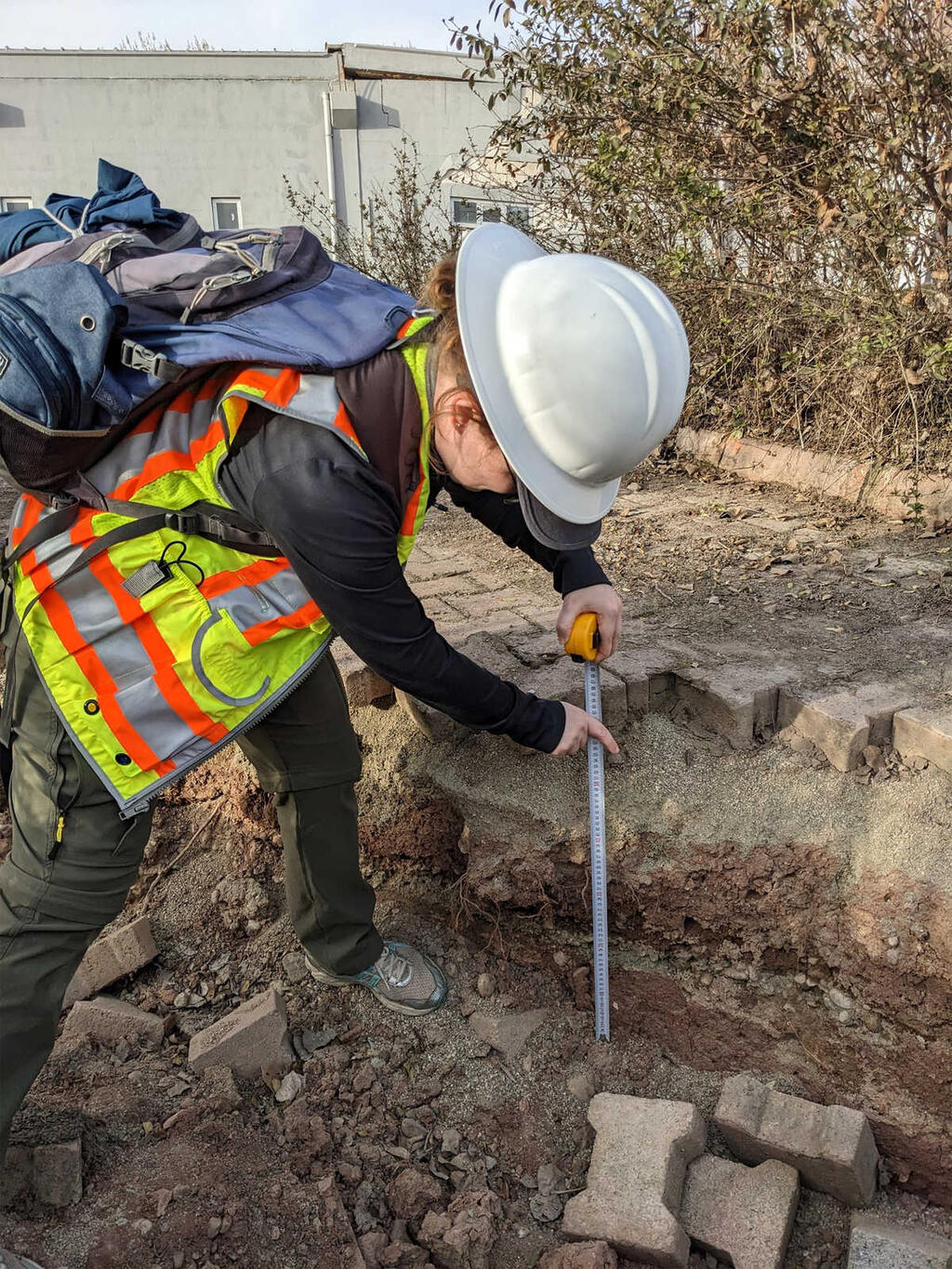
During her trip to Turkey after the powerful 2023 earthquakes, Dr. Ulmer and a team of researchers used various tools to collect data, including drones, cameras and tape measures as shown here, as she records the depth of a crack in a walkway.
Dr. Kristin Ulmer (KU): My pleasure. Thank you.
LP: So just after the devastating earthquakes, you got an opportunity to conduct research on site in the midst of the disaster zone. The Earthquake Engineering Research Institute mobilized this reconnaissance team. So how did the opportunity to be part of that team come to be?
KU: So like many people, I was watching the events unfolding on TV, feeling shocked, honestly, by the magnitude of the devastation. The members of the Geotechnical Extreme Events Reconnaissance membership, it's an NSF-sponsored group that goes out and does reconnaissance work after events like this, sent out a general question to the membership of that group. I had become a member some time before then. That email I responded to, saying I would be interested and available. I got an email saying, we're putting the team together. It was a Monday. Can you leave this weekend, right?
LP: Wow.
KU: So I responded yep, and fortunately, management here at Southwest Research Institute helped me quickly get ready to go.
LP: So there was no time to waste. You wanted to get there soon after the earthquakes happened. So what was the goal for traveling there to gather data at that time? Why was it so important to be there right after those earthquakes?
KU: After an earthquake, there are all sorts of ways that the earth responds, different ways that the ground moves, deforms, cracks, the way that buildings then respond to that same change in the earth. And those things can change quickly thereafter, right? There's a lot of cleanup. There's a lot of changing in weather that can wash away certain effects that we need to see in the soil. So it's important for us to get there quickly. And particularly for these sort of earthquake events, it's not something we can necessarily recreate in the lab. In the lab, we can look at a small scale or relatively small scale, but you can't necessarily recreate what you see out there in the field, where you have these gigantic tectonic plates moving and you have entire countries totally changed in the landscape. So it's really important for us to go out and quickly gather that information so that we can advance our understanding of earthquakes.
LP: So you're seeing this widespread damage firsthand, so important for your research. So how long were you there?
KU: I arrived after some long travel on a Tuesday morning, got to work immediately, spent Tuesday, Wednesday, Thursday, Friday, and Saturday just canvassing the entire area, trying to find observations of liquefaction and other types of ground failures.
Image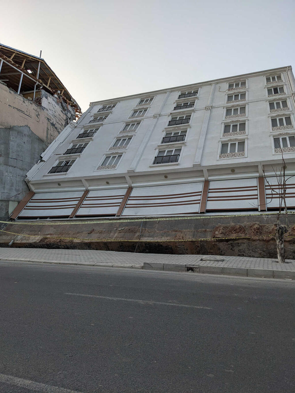
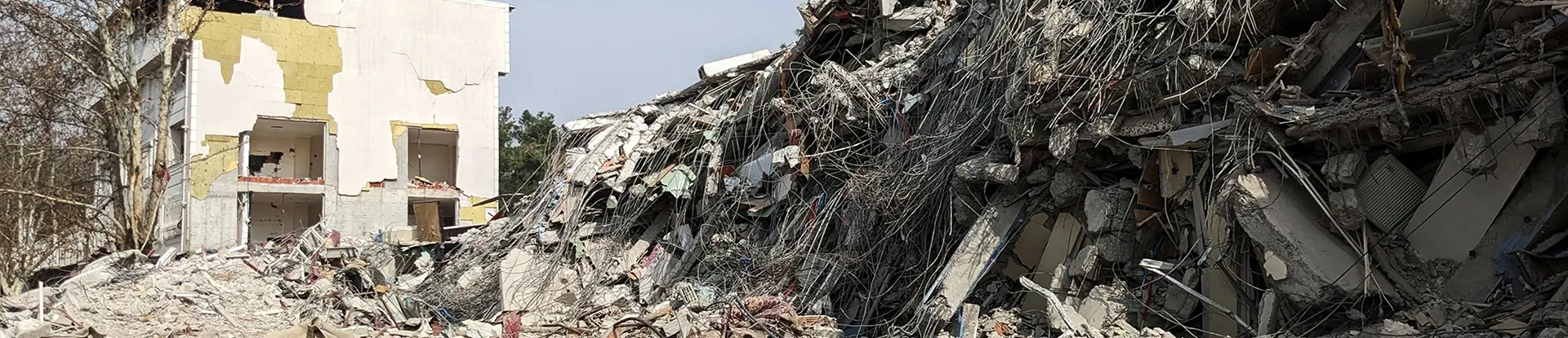
Dr. Ulmer encountered widespread destruction during her 2023 research visit to Turkey. Here, a building is collapsing due to liquefaction, a dangerous process that causes solid ground to behave like a liquid.
LP: So you were there just a few days. You're still going through that data. We're going to talk to you a little bit more about that coming up. But tell us about your travel there. How did you get there? I imagine it was tough to navigate through that destruction and ruin. Where did you stay? How did you get food and water? How did you live those few days in that sort of disaster area?
KU: Really great question. Getting there, fortunately, there was an airport in Gaziantep that was operating relatively normally, so able to book a flight and arrive in the country, which on its own was a big journey. And then once we got there, the area where the damage was most severe didn't have great plumbing, electricity, access to food, water, things like that. So what we did is we would station ourselves in a city outside of that area where it was most significant where we could easily station our stuff and find water, find supplies. Every day, we'd pack up our car full of everything we needed for the entire day, drive in maybe an hour and a half to where we were going to be for that day, spend all the daylight hours we could in the area, and as soon as it was dark, head out and be back at our hotel for the evening and do it all over again the next day.
LP: Basically just living out of a car.
KU: Correct.
LP: All right, so once you arrived, you and your team got to work. What was your priority while you were there? What was your focus?
KU: So our team's focus was looking for evidence of liquefaction and other ground failures that were caused by the earthquake. There was another team that was there following the earthquake trace and making sure they could map where the fault was visible at the ground surface, but our focus was looking at liquefaction, ground failures and how those affected foundations and other infrastructure.
LP: All right, so we want to get some quick definitions to understand your work better. You've mentioned liquefaction a couple of times. How do you define liquefaction? What is it?
KU: Right. Liquefaction in soil is a phenomena that can occur when the shaking is strong enough, if you get enough earthquake shaking, it sends these vibrations into the soil. The way the soil particles move creates higher water pressures in between those soil particles, and that basically makes the soil start to behave more like a fluid than a sort of solid structure that we tend to build things on. And once that happens, then the soil behaves more like a fluid. You lose a lot of strength, a lot of capacity to hold up things that we build on the soil. And that can lead to a lot of different consequences we would like to avoid.
LP: So another definition I wanted to get before we really get into the conversation about your work is lateral spread. What is lateral spread? I know you'll touch on that in a bit.
KU: Absolutely. Lateral spread is one of those consequences of liquefaction that can happen. Imagine a cake with many layers. Say the top layer is dry and relatively stiff and strong, but a layer underneath that surficial stiff layer, say that liquefies. And so the stiff layer on the top of the cake is moving on top of a soft, fluid-like layer, and that can tend to lead to pieces of that top layer breaking apart. You get cracks. You get sunken blocks. You get a lot of movement. Typically, it happens close to some sort of edge, like a river bank or a lake, where you have an open face for that ground to move into. And that's where you typically see those kind of lateral spread cracks.
LP: OK, so you're going through the disaster zone, you're looking for very specific features. You're bulking up your research to bring back and to sift through. But while you were there, were you worried that an earthquake would happen again? There were so many aftershocks and two big earthquakes back to back. Were you concerned about your safety while you were there?
KU: Aftershocks were certainly on our mind. And in part, that's one reason why we made sure we scoped out the locations we stayed at. We wanted to make sure that they were safe. We also did feel, actually, a couple of aftershocks. There was one aftershock I felt while we were out in the middle of nowhere, pretty much, but actually quite close to where the fault manifested at the ground surface. And I remember feeling the ground move under my feet for just a moment, just a very small moment. I think it was a magnitude 6 or something. After the fact, we found out that it was. And I thought
LP: That sounds pretty big.
Image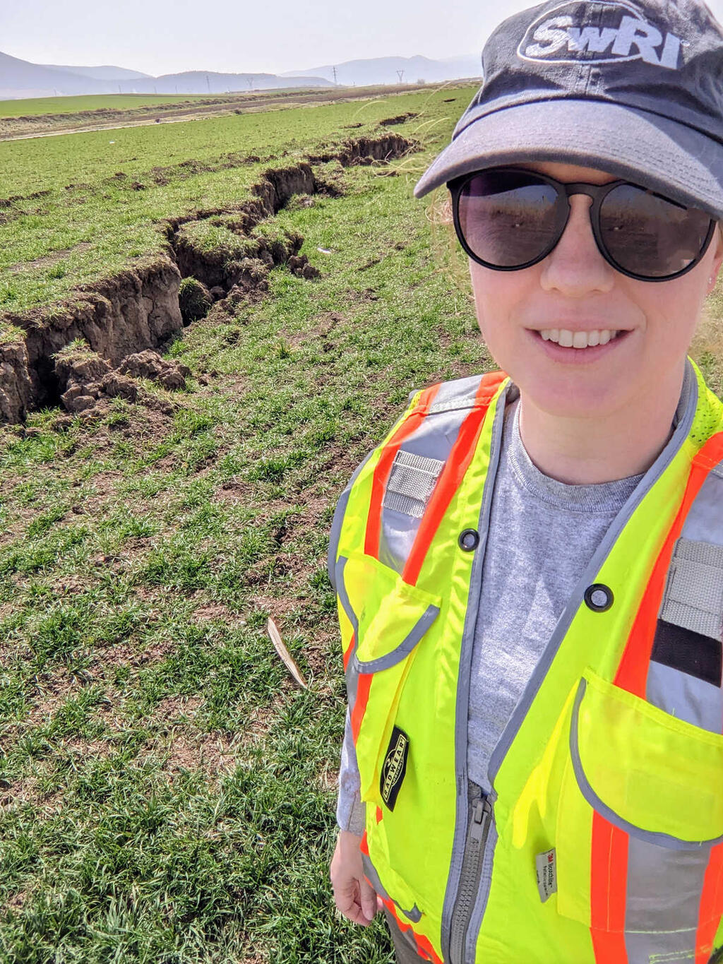
Dr. Ulmer stands near a surface rupture caused by the February 2023 earthquakes in Turkey.
KU: It sounds big. It sounds big. I didn't fall over, fortunately, but I remember thinking that was the first time I remember feeling an earthquake that strong in my life. So that was important for me.
LP: And for studying earthquakes and researching earthquakes, I guess that was a big moment for you, to experience that for the first time.
KU: Absolutely, yes.
LP: So okay, let's talk about your research, the reason you were there. You're collecting data to, as I said, bring back and go through and hopefully improve processes in the future. But how are you conducting this research? Can you walk us through a typical day during your stay there? What tools or methods did you use, and what did you find?
KU: Sure. We were out there, not knowing where we needed to go to find this evidence of liquefaction. We had to rely a lot on people helping us find this. We would go to a place where we anticipated seeing something. We would bring along our personal protective equipment. Of course, we had our hard hats, our steel toed boots, and our protective glasses. And we grabbed our notebooks. Our phones have quite a few helpful apps for taking photos, GPS tracking, and keeping track of where you are and what you're looking at, and which direction you're looking at things. And then we brought some drones to help us capture some footage above the ground at a scale where we could take many, many, many photos and stitch them together to create a 3D model after the fact, right? So we were collecting just as much photographic evidence, text descriptions, measurements with our tape measure of cracks, of displacements. Anything we could find, we would be documenting it as much as possible.
LP: So I know we talked about this. You're looking closely at the soil. What does the soil tell you?
KU: So liquefaction itself tends to happen more frequently and more reliably in certain types of soil. So we look at the composition of the soil in terms of soil particles. So does it have more sand or gravel? Does it have clay or silt? Those different soil particles behave a little bit differently under earthquake shaking. Also, we pay attention to the topography of the ground. Do we have a slope? Do we have flat conditions? Do we have buildings nearby where the foundation's interacting with the soil make things change?
We also pay attention to where's the water. One important thing for liquefaction is you do need water saturation to initiate liquefaction. So we're paying attention to are we near a lake, are we near a river? Are we near some where we know the groundwater table is relatively close to the surface? And we're also paying attention to the layering of the soil because the way different soil layers interact might change whether or not liquefaction will start in a particular layer. You can imagine if you have a stronger layer over a softer layer, or the other way around, a softer layer above a stronger layer, they might behave a little bit differently in an earthquake. So those are the things we're looking at.
LP: OK, so it's, here we are in April 2024. It's been over a year since your trip. So what have you learned from the data you gathered, all those measurements, the photos, all that evidence? Are you still, as we mentioned, you are still sifting through the information. So what have you learned, and what is yet to be discovered?
KU: There are a couple of things we're still trying to figure out and still sifting through. It takes a lot of time to figure this out. And I'll add that a lot of the data we collected is just what we could see. But in our work, it's important to also see or to understand what's below the surface. So taking actual heavy equipment out there to drill boring logs and to take measurements of the soil strength in place out in the field is important, and that's something that takes months afterward to happen. So a lot of what we did is identify places of interest where then these more in depth studies could occur later on. And so those things have been going on over the last year or so. We have found interesting instances of liquefaction occurring in soils where we maybe didn't think it was as likely before, particular soil types with more fine content. When I say fine content, I mean like this clay and the silt rather than sand particles, which tend to be bigger and behave a little differently.
So we're still working on that. But I think what we're learning and what we're going to get out of this data gathering experience is just more case histories to add to our collection of case histories, which is what we're calling sort of a collection of observations after an earthquake in the past. We have many, many decades of earthquakes that we have documented case histories for. This adds to that, and helping us better understand the broader scope of earthquake impacts and helping researchers be able to say, I have this question about liquefaction and I need data in order to test my hypothesis, or in order to figure out if I'm on the right track. This set of case histories we've gathered will then become part of that library of information that researchers can draw from when they're trying to answer those questions.
LP: And ultimately, the goal is to preserve communities and to save lives, so can you connect the dots for us? How does going out there and studying the soil and taking these measurements and collecting this information, how does it link back to one day, hopefully, saving lives and keeping buildings from falling? How do those two connect?
KU: Absolutely. So the researchers who are able to look at these case histories and say, liquefaction happened here but it didn't happen here. Why is that, and can we try to engineer our foundations and our soils to not liquefy in future events? So if we're worried about liquefaction in an area where we're building some infrastructure, buildings, or energy production facilities, can we be able to predict if liquefaction will or will not happen, first of all? And then once we know whether or not it would or would not happen, what can we do to lessen the effects or to remove the problem entirely? What can we do?
LP: So the goal is to perhaps choose to build in areas where liquefaction is less likely.
KU: And if we do have to build in areas where there will be liquefaction, what can we do about it?
LP: Are some of the solutions maybe shorter buildings in these specific areas or different materials being used in high liquefaction, where there's a high possibility of liquefaction? Are those, what would be some hypothetical solutions to deal with a high liquefaction area?
KU: Yeah, sure. Some of it can be designing a foundation that can go deeper than the layer of soil that we think will liquefy, so going to some more competent material. And so then you have these basically deep pier foundations that can hold up a building and avoid the issue of liquefaction. You can also have soil remediation. So you can mix in different materials with the soil to basically change its properties so that it can be stronger, so that the water can escape more easily and not cause liquefaction in the first place. There are also drains you can install that basically allow the water to get out, which then means that it's not going to be contributing to liquefaction as much as it would have otherwise. So there's a lot of things we can do to change the landscape of your site where you're trying to build and avoid issues with liquefaction.
LP: Are some of these methods already being employed?
KU: Yes, some are. I think in a lot of cases if liquefaction is highly likely, people choose not to build there. But in the cases where you don't have that choice, there are definitely those kind of remediations that people use.
LP: Anything new on the horizon to deal with liquefaction? Like, what's the up and coming technology?
KU: That's a great question. I've heard of a lot of researchers looking into microbial-induced calcification of soil, so basically trying to cement your soils by these bacteria that produce different chemicals, and this chemical reaction cements the soil so that it's not going to liquefy. It'll be a really strong material. So the idea is that you could inject the food that this bacteria feeds off of, and the bacteria would then basically cement your soil for you.
LP: That's really cool.
KU: Yeah, really cool. I don't know of any commercial application of that so far. I think it's still in a lot of research.
LP: In a study phase.
KU: But it's really interesting stuff.
LP: When will your analysis of your data wrap up, and what will you provide at the end? Are you looking at writing papers, or what are you looking toward?
KU: So we did produce a report. The GEER organization produced a report last year basically summarizing all of our findings at just a real basic level. And we have put out a couple of papers on what we found, some of the interesting deformations of foundations in some of the cities we visited. We also are trying to take a look at some of the sites where we saw liquefaction in one place but not in another, trying to understand those situations a little bit better. And next week, I'll be presenting at a conference. And honestly, the work of presenting these results will continue for some time after now.
LP: There's a lot of interest in what you've uncovered and what the team has found. So what do you foresee as the outcome of this research? We talked a little bit about improving building safety, but how can it help in other areas rattled by earthquakes outside of Turkey, maybe globally?
KU: Right. I think a lot of other places in the world that maybe have a similar potential of earthquakes and soils that are susceptible to liquefaction and hopefully improved building practices and codes. They can look at what we saw in Turkey last year and have it be an opportunity to revisit what their current practices are and try to improve them.
LP: All right, so as we mentioned, the earthquake devastation was immense. More than 50,000 people died. Estimates indicate there was $100 billion in financial loss, huge. So when you arrived, you were also faced with the people who lived through the devastation. It wasn't all about collecting information for you. There was a real human element to your technical work. Tell us about your experiences meeting the local people, the earthquake victims. Are there any encounters that have stayed with you?
KU: Sure. I think this is maybe the most unique part of this experience for me. Most of my research up to that point had been sitting at a computer and reading about these sort of events and seeing photos of what had happened. So being able to go there and physically see it for myself, see my first observation of hey, liquefaction happened here, was new for me. But most importantly, seeing the people that were living around the area that was impacted so heavily was eye opening for me and taught me a lot. I remember several people we met. Unfortunately, I couldn't speak the language. I could only occasionally say hello. I could say "meribah," and that was about as good as I could do. We had a member of our team who grew up in Turkey and could translate for us, and that was absolutely critical for us to be able to find what we needed to find.
So we would often arrive in a place where we thought we might find something, talk to somebody who was nearby and say, hey, have you seen anything like this? And they would often say, yes, over there, and then they would point us in the right direction. One of those instances was a man and his wife that lived in a home in a town called Gölbasi, and their house was standing. It seemed to be doing fine, had maybe some minor superficial aesthetic damage, but fortunately, they were safe. They had a little couple of peach trees in their front yard, and they absolutely insisted we have some of their peach juice because they were worried that we were working hard and getting too hot and thirsty out in the sun. They helped us find some really significant lateral spreading feature on the side of a lake where there was a university campus affected.
So meeting with them, though, was so, it's hard to put into words, honestly. But just meeting them and seeing how they were so kind to us. They really treated us so well, despite the fact that they had just had their world rocked. They had it literally changed, and their neighborhood had so much damage. There was a set of tents just within eyesight of their front yard where people were living because their houses had been destroyed. So imagining what their life was now, where they couldn't have access to the normal everyday things they used to have, and yet they wanted us to sit in their front yard and drink some peach juice with them and talk about normal things.
LP: I'm sure you can still see their faces and maybe even remember the taste of the peach juice. You don't have peach juice too often.
KU: It was quite good.
LP: Well, that's a really sweet story, and really, I think, humanizes your research efforts. Because I think at the end of the day, at the core of what you do, is to help people like those two that you met in Turkey. So you and your research team are doing important work that, as we said, hopefully one day will save lives and improve construction to prevent, we can't prevent earthquakes, but we can prevent, hopefully, some of the damage that they cause is your goal.
KU: That is our goal.
LP: So as we said, earthquakes are unpredictable. You never know when they're going to strike. You want to get there as soon as you can after one occurs so you can really get that good information, that data you need to continue to learn about them. Another opportunity popping up this month, an earthquake making headlines this month in Taiwan, magnitude 7.4. So you hear about this earthquake. What are your thoughts on that one that just occurred?
KU: Hearing about an earthquake in Taiwan makes me think of the last one that we're, at least in the liquefaction research community, are fairly familiar with in 1999, which happened in that country and led to a lot of widespread damage. So you can have these memories come up of what we've seen before and wonder how did things happen this time? How is it different? How is it the same? What can we learn from this event in not exactly the same location, but pretty close to the same location as the past event? So those are some of the things I'm thinking of. And I'm really hoping that recovery will go well for them in these really early, early days.
LP: So as you said, the biggest earthquake in 25 years. And I'm sure some things never get rebuilt. Some things take decades to rebuild. So there very well may be families that it's still very fresh to them what happened 25 years ago. So here they are again. So yes, our thoughts are with them as they recover. Do you think you would have the opportunity to go there and look at that area?
KU: It's a good question. We'll see what the organizations decide to do, whether they will send out teams and who will be on them, but there's definitely a likelihood of some group going out there to gather some more information and see how things are similar or different this time.
LP: All right, something to keep watching. So we celebrate Earth Day this month, on April 22. The day brings awareness to ways we can protect the planet, and it calls for change to mitigate the negative impacts of harmful environmental practices. Those practices are leading to effects like warmer temperatures, changing weather patterns, and melting ice caps. Now, you're seeing the direct impact of these changes in your research. So what types of effects have you noted from changes in weather?
KU: What I'm hearing a lot more in different research circles is what can we do with a changing baseline, right? So if we're used to the sea level being at a certain level and the soils in one area being a saturated to a certain point, we can run our liquefaction analysis and make predictions, say oh, this area, high likelihood, this area, low likelihood. But if the sea level changes, say if it rises some amount, then that sort of prediction will have to change, too, right? So we're wondering, how do we respond to potential differences in our baseline going forward in terms of sea level? It can be in terms of permafrost in some areas where the soil that normally stays frozen in some of the northern parts of our world are now not necessarily staying frozen, so this will behave differently when it's no longer frozen. And how does that change their risks of liquefaction or other earthquake-related hazards? So things that we use to maybe take for granted are not necessarily always the same. And so now we have to learn how to respond to that and plan for what could be in the future.
LP: What was your journey to where you are now, and how did you become interested in this field?
KU: I was an undergraduate student as a teaching assistant for a soil mechanics lab where I discovered I kind of liked working with soils. Soils are complex. They're not engineered in the same way we might engineer steel or concrete, where we have maybe some more knowns. There's a little bit more unknowns in the way that soil will behave. And so I was very intrigued by that complexity, and I decided, you know, I'd like to go to grad school. I started working with a professor at my university who had a project where we would be developing new liquefaction methods that could be easily accessible to practicing engineers. And I thought it was a great project. I learned a lot. And once I added the complexity of soils with the complexity of earthquakes, the grand scale of tectonic plates all the way down to the microscale of looking at soil particles and how they interact, I just fell in love. And that's where I started.
LP: I really love getting to know the back stories of our scientists and engineers, and a lot of times I find, just like you did right now, you light up at your chosen field and what you have chosen to do. And I can tell you really care about it and you're really interested in it. So that's great to hear a little bit about your journey there. What's your advice for a young person today who might want to follow that path, who is really intrigued with what they're seeing with what the Earth can do?
KU: That's a great question. Find what you enjoy and find someone who knows something about it and learn all you can from them. There's a wealth of knowledge from professors, from other practicing engineers, researchers, scientists. And there's all these opportunities to learn online from all these experts and go learn from them and then just keep your eyes open at the world around you.
LP: That's great advice in any field, really.
KU: True.
LP: So Kristin, before we go, I do want to mention you are a 2024 recipient of the EERI Younger Member Award in recognition of your impactful contributions to fundamental and applied research in soil liquefaction and your commitment to the earthquake engineering profession. Now, EERI is the Earthquake Engineering Research Institute, a technical society, the same society that led the mission in Turkey that you participated in. So congratulations on this honor. What does this recognition mean for you and the future of your research?
KU: Well, it's first very humbling. I know a lot of younger members of this Institute are doing great work, so it's exciting to see our group being recognized. And having a spotlight on the kind of work that I do, I hope, will just make it apparent to the world that this is important research to be done, and there's still more to do. And it's exciting to keep going and keep learning and keep making our world safer.
LP: Definitely. Again, such important work you and the research team are doing to get us good data about what happens after an earthquake and how to protect our communities. So you can learn more about SwRI's earthquake research on Episode 11 of the Technology Today podcast. Again, great information and work that could help save lives and protect homes and buildings from earthquake destruction in the future. Thank you so much for telling us about your research today, Kristin.
KU: Thank you for the chance.
And thank you to our listeners for learning along with us today. You can hear all of our Technology Today episodes, and see photos, and complete transcripts at podcast.swri.org. Remember to share our podcast and subscribe on your favorite podcast platform.
Want to see what else we're up to? Connect with Southwest Research Institute on Facebook, Instagram, X, LinkedIn, and YouTube. Check out the Technology Today Magazine at technologytoday.swri.org. And now is a great time to become an SwRI problem solver. Visit our career page at SwRI.jobs.
Ian McKinney and Bryan Ortiz are the podcast audio engineers and editors. And sometimes, co-host. I am producer and host, Lisa Peña.
Thanks for listening.
[MUSIC PLAYING]
SwRI is part of the Next-Generation Liquefaction Consortium. The consortium combines case history data with liquefaction modeling to predict liquefaction triggering and related consequences.
How to Listen
Listen on Apple Podcasts, or via the SoundCloud media player above.