
Background
Photorealistic digital reconstructions of outcrop geology, or “digital outcrops,” are increasingly being used for geological research and education. These datasets can be acquired and generated relatively rapidly, providing large volumes of geometric and textural information for geologic analysis. Despite the growing popularity and potential of digital outcrops for geoscience research and education, even basic analysis of these datasets requires specialist software and significant user expertise, and existing web-based three-dimensional (3D) viewers are not optimized for geological visualization or analysis. To address these obstacles, we developed a web-based 3D interface optimized for visualizing, interpreting, and analyzing digital outcrops. The ultimate objective of this project was to develop a proof-of-principle prototype tool for 3D data visualization and analysis and to leverage this work to (i) secure external funding from the National Science Foundation Geoinformatics program, and (ii) augment and improve existing SwRI training courses offered to commercial clients.
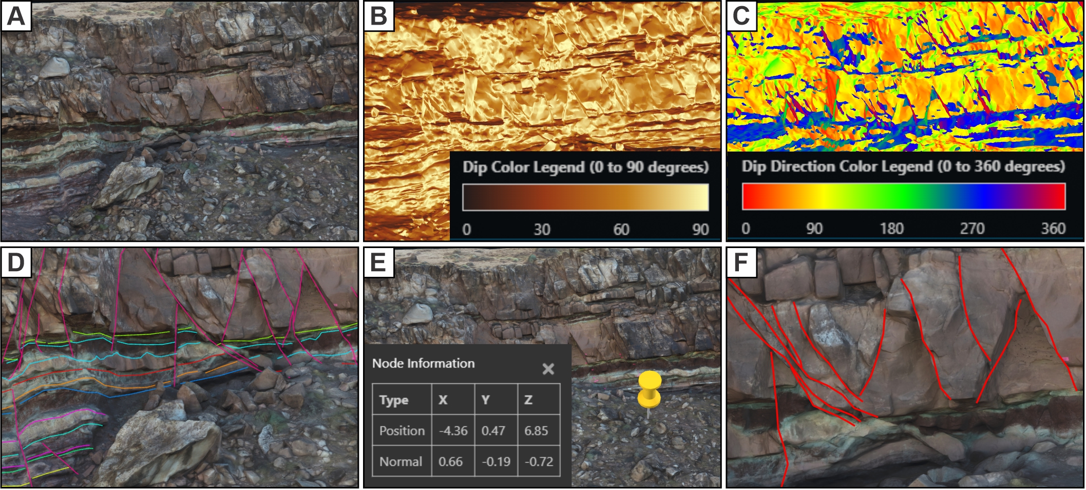
Figure 1: Modifications to adapt the Voyager tool for geoscience applications. (A) Digital outcrop in the modified viewer. (B) Dip magnitude shader with customizable color ramp. (C) Dip direction shader. (D) Digital outcrop and imported polyline interpretations. (E) Point-and-click model geometry query tool. (F) Online interpretation tool.
Approach
This project focused on development of prototype technologies that leverage existing 3D viewer applications to improve browser-based geometric visualization and analysis of 3D point-cloud and textured mesh datasets. This was achieved by adapting the Smithsonian Institute’s Voyager 3D viewer to develop a working prototype that provides users with a dynamic and interactive way to explore digital outcrop data. Specific tasks for the project included (i) generating a routine to import and display multiple 3D models, (ii) enable toggling on and off of specific objects within the multi-model environment, (iii) enabling import and display of multiple 3D geologic interpretations (as polylines or polygons) as an overlay on digital mesh surfaces, (iv) modifying color shaders to allow models to be colored by orientation using geologic conventions, (v) developing a “point and click” tool whereby the geometric properties of a mesh triangle (e.g., orientation) can be queried and displayed, and (vi) developing a digitization tool that allows 3D line interpretations to be generated within the 3D viewer.
Accomplishments
Overall, the project was successful, with most of the technical sub-tasks achieved. We made six key modifications to the viewer, developed seven working prototypes, and retained the geometric fidelity, scale and orientation of all 3D datasets upon import into the modified 3D viewer. Our seven working prototypes highlight the flexibility of the 3D viewer for displaying digital objects of variable spatial scales, resolutions, and types. These examples demonstrate that rock samples, geologic outcrops, and laboratory datasets can all be displayed in the viewer. Third-party, open access datasets can also be leveraged and displayed through the viewer without the need for re-acquiring data, and alternative scanning methods can be utilized to acquire data for displaying in the viewer. This flexibility, along with our developed modifications, provide the potential to display a wide range of data types within the modified viewer.